


- Multiple receiver vessels, with individual receiver inventories
- Battery life heat map
- Reduce survey duration with new receiver handling efficiency settings
- Turn pattern optimiser
- Improved vessel scheduling, with automatic optimisations
- No more “not enough receivers” errors
- Increase rolling spread width
- More realistic understanding of receiver lines
- More SPS export options
- Relative file paths
- Minor improvements and bug fixes
Compatibility
Due to the extensive changes in release 2.8.0, SFP versions 2.7.0 and earlier will not be able to open project files saved in 2.8.0.
On opening an older file in 2.8.0, SFP will automatically adjust project settings to take account of the changes, and will open the Survey Parameters dialog for you to check and confirm the adjustments.
If you require assistance in working with projects that were created in older versions of SFP, please contact us.
Multiple receiver vessels with individual receiver inventories
Seafloor Planner now supports multiple receiver vessels working together. The new turn pattern improvements and scheduling optimisations make it easy to manage workload between vessels.
Each vessel has its own starting inventory of receivers, and SFP keeps track of the number on board. If one vessel runs out of receivers while there are still receivers available on another vessel, SFP will try to adjust the lay/collect tasks to balance them. If this is not possible, an alert will be generated and the problem areas highlighted.

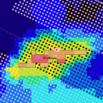
Battery life heat map
A battery life heat map can be displayed, showing the current battery life of every receiver at any point in the survey. Recovered receivers show the battery state at recovery time.
Handy new statistics show the min, max and average battery life remaining at recovery time, as well as the number of receivers with expired batteries. A warning will also be displayed on the Alerts panel if any batteries expire.

New receiver handling efficiency settings
The new “Collect Together” efficiency setting can be used to save collection tasks till several lines are available can minimise unnecessary crossing of the active patch. This can reduce source vessel wait time and overall survey duration.
“ASAP” and “Just-in-time” settings are now available for laying and collecting: When battery life is a consideration, these settings can be used to model the lowest possible durations for nodes to stay on the ocean floor, by deploying just in time for shooting, and collecting as soon as possible. Alternatively, you might choose to deploy ASAP and collect just in time, to allow for small variations in shooting schedule.
Turn pattern optimiser
By default, Seafloor Planner will automatically test out different vessel turn patterns, and choose the one that results in the shortest overall survey duration.
Optimisations include automatic balancing of vessel workload, such as allocating more lines to faster vessels or to receiver vessels that have more receivers on board, and automatically selecting an efficient racetrack width based on vessel turn radius.
Full or partial manual configuration is also available, using a range of new turn pattern settings.

Improved vessel scheduling, with automatic optimisations
A range of vessel scheduling improvements have been introduced under the hood, helping minimise vessel wait time and reduce overall survey duration. These include:
- Source vessels will wait to start a line until they can complete it without pausing or contravening minimum separation rules.
- When a source vessel needs to wait (to maintain minimum separation), the vessel on the critical path is given priority.
- Vessel workload (distribution of tasks) is automatically optimised, both for source and receiver vessels, to minimise vessel wait time and to allocate lay tasks to vessels that have enough receivers on board.
No more “not enough receivers” errors
If there are not enough receivers to create the survey plan, SFP will now build the survey “as though” there are enough receivers: A warning on the Alerts panel will state how many additional receivers are needed, the map will show visually exactly where in the survey the shortfall occurs, and lay tasks in the timeline that involve shortfall receivers will be highlighted with a purple bottom border.
This will also occur in a multi-vessel survey where there are not enough receivers on board an individual vessel to complete a lay task, if attempts to allocate lay tasks to other vessels fail.

Increase rolling spread width
The new “increase spread” option for rolling spread (progressive shooting) surveys adds additional receiver lines to the active spread. This allows the center shooting source vessel more space to do efficient racetracks, reducing the need for teardrop turns and potentially reducing the overall duration of source-bound surveys.

More realistic understanding of receiver lines
Previously when using ROVs, receiver lines were represented internally by merging them together. Now Seafloor Planner maintains separate receiver lines, while creating sail lines for the receiver vessel, with drop points for receivers. This more realistic model improves the accuracy of statistics and CSV exports. It also paves the way for future support of new node technologies such as autonomous nodes.
More SPS export options
SPS exports have been collated into a single dialog, with some new options:
- All deployed receivers at the time of a shot point can be exported as though they are required, including receivers that have been laid ahead in preparation for future shot points, and receivers that are waiting to be collected. This can be useful when importing the XPS file into analysis software.
- SPS and RPS files can be exported without an XPS relationship file: This is handy when only source and receiver points are required.

Relative file paths
Input files, such as SPS files and receiver or source area polygons, can now be saved using relative paths: Simply tick the “Use relative paths” box when browsing for the file. For example, with relative paths, a file might be saved as “receiver_lines.rps” instead of “C:\Users\fred\Documents\OBN\MySurvey\receiver_lines.rps”.
Relative paths can better support file sharing systems such as Sharepoint, or emailing of project files with accompanying input files.
Minor improvements and bug fixes
- Usability: Receivers that can’t be laid or collected due to obstructions are now counted and reported in the Summary statistics panel.
- Usability: Several new statistics are available in the Summary and Simulation statistics panels.
- Usability: Obstruction safety margins are now 0 by default, to avoid unintended expansion of an obstruction.
- Usability: When exiting a project or starting a new project, you’ll be asked if you want to save your changes first.
- Usability: Features that were previously only accessible by right-click in the map have been added to the Edit menu. Includes tiles, source patterns, obstructions, bathymetry, and background image.
- Usability: When a vessel is selected in the map, its tasks (i.e. lines and turns) are now highlighted.
- Fixed: “Current patch only” display resets after each survey build.
- Fixed: Receivers just inside the offsets are excluded from the active patch in some ROV rolling spread surveys.
Other changes
The patch optimiser for overlapping patch style surveys has been disabled, as it was not compatible with the new file format and we believe it was rarely used. (Do let us know if it should be re-enabled as is.) In its place, a new tile optimiser is planned for a future release.